Graveyard Coulee Drainage Project
Glendive, Montana
Glendive Public Schools retained Interstate Engineering to evaluate Graveyard Coulee through Dawson County High School’s property.
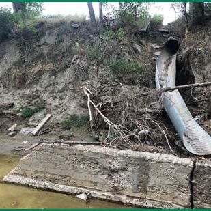
The project’s goal was to stem channel bank erosion through the property, restore stability to the parking lot, and reduce athletic field flooding. A secondary objective was to address surface drainage and bank erosion, potentially contributing to gym foundation movement and causing doors to stick around the building’s exterior.
Graveyard Coulee drains a basin over 2,000 acres that flows from Makoshika Park and through Glendive to the Yellowstone River. The drainageway bisects the high school’s property, separating the school buildings from the athletic fields. The drainageway is deeply incised with steep channel side slopes and frequently carries significant flows that flood onto the athletic field.
Interstate Engineering performed a topographic survey of the drainageway and adjacent property and performed channel hydrology using regression equations accepted by the Department of Natural Resources and Conservation. The basin’s boundaries were determined using Montana StreamStats and modified as necessary using the City of Glendive’s and Montana Department of Transportation’s storm drain system mapping. Expected design flows for the drainageway were developed for the 2-, 5-, 10-, 25-, 50-, and 100-year events.
We authored the final Preliminary Engineering Report (PER) in May 2019. The PER considered six alternative means to convey drainageway flows across high school property in addition to a no-action alternative. Alternatives ranged from completely enclosing the channel within a conduit (culvert) to armoring the entire channel to armoring only portions of the channel. All other options included raising the north/west channel bank to prevent flooding the athletic fields. Every option, including the no-action alternative, included improvements to surface drainage to prevent infiltration near the gym foundation and surface runoff from flowing down the channel banks.
Interstate Engineering solicited permitting agencies to comment on each alternative presented in the PER. Additionally, Interstate Engineering provided an estimated project cost for each option. The project cost included construction, design engineering, construction engineering, compensatory mitigation credits, and contingency. We presented a qualitative evaluation of each alternative, rating each alternative’s impacts and the ability to address Glendive Public Schools’ problems. Each alternative was scored on a scale of 1-5. Each option was evaluated for cost, mitigation requirements, wildlife impacts, aesthetics, and bank stability.
Alternate 6 was the preferred alternative, with an estimated project cost of $667,000. Under Alternate 6, only the toe of the channel side slope was proposed to be armored. The channel invert and side slopes would remain in a natural condition. Where appropriate, side slopes above the toe would be stabilized utilizing a turf reinforcement mat higher on the channel sides where vegetation is disturbed/removed to accommodate channel construction.

Interstate Engineering Team
Completion Date
- February 2020

