County Water District of Billings Heights
Billings, Montana
For over 13 years, Interstate Engineering has managed an active hydraulic water model for the County Water District of Billings Heights (CWDBH) and their water distribution system. The district utilizes the model for several tasks, including fire flow analysis, private development impact reviews, infrastructure design, and district growth planning.
THE “HEIGHTS”
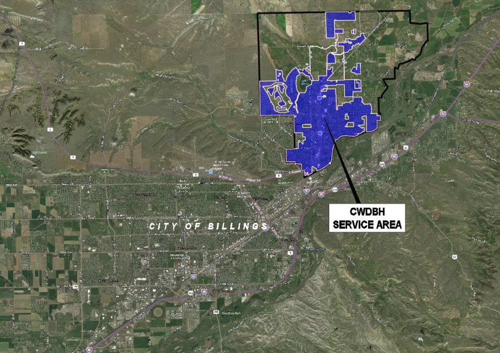
The Billings Heights (locally known as the “Heights”) is an area that encompasses approximately one-third of the population of Billings. This portion of the city is located above the “Rimrocks,” northeast of the airport and downtown area. In recent history, the Heights has experienced steady growth (mostly residential) and continues to expand northward.
CWDBH PAST & PRESENT
The County Water District of Billings Heights first developed its distribution infrastructure in the 1960s to serve the Heights’ growing potable water supply needs. After periods of significant urbanized growth, the Heights residents were annexed into the City of Billings in 1984. CWDBH remained the primary potable water supplier for a majority of the Heights area residents while the city began to provide other municipal services, such as sewer, solid waste collection, etc. The CWDBH potential service area covers over 15 square miles containing properties both within and outside the city limits.
Presently, CWDBH has a team fully staffed with management, maintenance, and administrative personnel to operate and maintain the water system. The system has grown to 120+ miles of distribution pipe, three reservoirs, and seven pump stations. The active service area covers over six square miles, with 5,600+ water service connections.
MODEL DEVELOPMENT
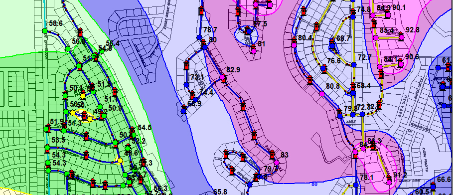
Interstate Engineering is an active partner with CWDBH providing engineering, atlas/GIS mapping, and hydraulic modeling services needed to manage their growing system. The district’s water model has been a longstanding staple for hydraulic review and system planning. Interstate utilizes KYPipe software as the primary water modeling tool when evaluating hydraulics. Furthermore, KYPipe has been recognized as one of the most widely used and trusted hydraulic analysis software worldwide. The district’s distribution system is completely modeled on a scaled mapping platform within the software. Pipe data was developed from atlas mapping, past plans, and record drawings. The model has a set coordinate system capable of displaying aerial background mapping and providing an accurate horizontal representation of the pipes. The model also utilizes open-source elevation data to establish approximate vertical locations of all pipes and system components. With these built-in data features, the model can provide relatively accurate and fast results without the immediate need for a field survey. Several other parameters can also be entered. Reservoir set-point levels, pump curve data, pipe head-loss characteristics, water demands, diurnal curves, and hydrant flow data can all be added to create more realistic hydraulic scenarios.
PUTTING THE WATER MODEL TO WORK
The district’s water model has become a readily available tool for numerous tasks, including performing a system hydrant analysis for projecting flows and pressures during fire simulations; evaluating reservoir storage capacity for fire demand and future growth; producing pressure availability maps displaying the system’s low and high-pressure potentials during a typical 24-hour period; simulate system surging/water-hammering events; evaluating pump station output and optimization; model the effects of pipe upsizing for rehabilitation projects; or size new waterlines for system growth. These are just a few examples of the many capabilities the model has to offer.
The district’s water model is the hydraulic data center when conducting preliminary engineering reports, project design reports, growth planning analysis, and new service impact reviews. Keeping a water model up-to-date is essential to maintaining its accurate output. The CWDBH model experiences constant change in water demand as a result of the area’s development. To manage system changes, CWDBH has a policy in place that requires all commercial and multi-residential developments to undergo a hydraulic modeling review before connection to their system. This practice has provided the district with the opportunity to review the development’s hydraulic impact on their system while also providing a program to keep the water model current. If a proposed development will negatively affect the system’s ability to provide the required flow and pressure, the developer is required to design and install upgrades to the water distribution system to mitigate those impacts.
LOOKING FORWARD
Minimal time and investment can yield powerful results. Having an active water model in place can provide useful data for growth planning, prioritizing projects, identifying hydraulic weaknesses, and finding the most cost-effective solutions. The water model has been a valuable tool for CWDBH and will continue to provide guidance as their system progresses into the future.

Interstate Engineering Team
Lowell Cutshaw, PE – Reviewing Engineer
Bill Enright, PE – Reviewing Engineer
Brad Boehm – Hydraulic Modeler


